JMT Roller Coaster Section - 07/2019
2019 was a heavy snow year and I had planned an early season trip which I had never done before. Up to the time I picked up my permit, I was nervously reading about trip reports and snow conditions and my findings were stark and grim. The consensus was that everything above 10,000' was mostly snow and the section I had planned was a 5 day trip from South Lake to Onion Valley which is often referred to as the "roller coaster" section of the John Muir Trail because 12,000' mountain passes scattered the trail every 10-15 miles or so. If you would look at the elevation analytics, it was look like repeating arches going from 8,000' to 12'000 back to 8,000' over and over again.

This trip was the first year I had actually made an effort to go ultralight. I was mentored from an old school backpacker (my Dad) from the 1970's wearing 65 pound packs with heavy boots. But here it was in 2019, I was pretty late to the scene, but I started minimizing my packing list to the bare essentials and replaced my boots with trail runners. I probably still had the heaviest pack on the trail, but I still felt like I was floating.
This year was also different in the fact that I actually did some training. A few short runs around the neighborhood and a couple of training hikes. I still wasn't sure if I would get my butt kicked or not, but I knew I'd have fun nonetheless.
Day 0:
I can't remember if I did a half day at work or not, but I drove up the 395 in the afternoon of 07/02 to get to bishop. I needed to buy micro-spikes in preparation for the snow and some trekking poles since I forgot mine at home.

I met a crowd of sunburnt hikers at Wilsons eastside sports and they gave me a much needed current snow report of the trail and it was still grim. Ultimately, they told me I'd fine with spikes and an axe. I didn't have an axe. Anyway, I got some food from Schats and then drove up to the south lake trailhead to sleep the night in my car and get acclimated. I looked up to the mountains from the trailhead and saw miles and miles of snow. Right there and then I told myself that I can always bail without shame and find something else to do for fun. I brought some climbing stuff and could always end up searching for a partner and exploring the hot springs. With that in mind and a pastry in my belly, I fell asleep with a plan to wake up and hit the trail before dawn.
Day 1:
The first half mile was done in the crisp dawn air which felt nice. Everything else after that was mostly in the snow. I found it surprisingly enjoyable to cross the snow banks until I made it to my first crux. Almost at the top of bishop pass is a large steep slushy snowfield where I had to hike up. I had thought to myself that this was a potential turning point but I decided to move on step by step. 5 minutes later, I was on top of the pass with no worries and the views of dusy basin and the palisades were immaculate. I truly have never seen this amount of snow in the mountains even though I was familiar with the landscape. Hiking through dusy basin was a dusy. Every other step through the snow I was post-holing to my waist and I had to use my poles to push myself out of it often times resulting in post-holing my other foot and then just being sunk in the snow. This went on for a few miles until I cross country hiked on top of this dry hill that I had suspected to be quite dry on its south slope. Sure enough it was and I had learned how important choosing the route was. I was alone in the backcountry without any cell phone reception (or GPS device) and choosing to leave the trail on my own freewill... seemed backwards.


A couple of other hikes on top of bishop pass had warned me of a big river crossing while going down into LeConte meadows. They explained it as either weight deep and moving swiftly or just cross country on the other side completely. I chose to cross country and ended up hiking about a mile stepping down big granite slopes and ledges. My rock climbing capabilities proved to be pretty handy so I can travel fast through this difficult and potentially dangerous terrain. I scoped out the trail again and met up with is at around 9700' and then followed that comfortably down to the meadows.

At around 5pm I found a good camp, set up my hammock and shelter, and began making some food. An hour later, a young man named Noah walked up and asked to share my camp in which I agreed. Then about 5 of his other hiker friends show up and all crowd up the place. Your typical PCT hiker set out on the trail alone, but actually hiked with large groups of sometimes up to 10 people. In my honest (and crusty) opinion, large crowds are one of the worst things that could happen in the backcountry for environmental and social reasons. The usual quiet and peaceful scenery turned into a dick measuring contest. Conversations were about mileage, cold-soaking food, ultralight geeky things, and then I stopped paying attention and went to sleep. This was one of the only nights I had a fire. My sleeping setup didn't work quite right either. My sleeping pad slipped out of the hammock and I kept waking up cold from the wind underneath me.

Day 2:
For my 2nd day, I decided to move slow and prepare for the crux of the whole trip, Mather Pass. Supposedly, Mather pass had turned away about 50% of hikers because of it's steep and technical south slope. It was steep snow and rock and a high elevation of 12,200. On my second day, I wanted to set myself up to climb up Mather Pass early in the morning while the snow was in good conditions. Noah and his hiker friends all left at 3:30am so they could get over Bishop Pass and back into town to celebrate the 4th of July but I decided to celebrate by hiking in the Sierras by myself (Good idea, huh?). It was a beautiful bluebird day in the mountains and there was a surprising amount of snow even at the lowest elevation of 8,100'.


In the section of trail I was in, there is a 1 mile section where about 1,200' is gained called the "Golden Staircase". The trail had turned into a stream and I'm glad I had quick drying shoes because it made more sense to hike right through the stream instead of trying to stay dry. As soon as I completed this steep section, everything was white. I was hiking through snow and an actual trail was nowhere in sight. It was beautiful, but I was concerned where I would make camp. In my bliss, I hiked all the way to lower palisade lake and then kept going past upper palisade lake. I have no idea what I was thinking because after this was a giant snow field up to Mather Pass and where was I going to camp? All I had was a hammock, a tarp, and a 30 degree down sleeping bag. Setting up in the snow would be suicide, so I was aggressively searching every patch of trees looking for clearings but not seeing any. I stayed hopeful and then at 10'800', I finally found a large clearing in the snow with some trees where I could set up a sweet camp. It was only 4pm or so, so I had plenty of time to make food, filter water, and enjoy the area.

The crazy PCT hikers were hiking past my camp until it got dark and then they kept hiking through. Even though I was nervous for the big Mather Pass the next day, I was pretty excited to be where I was and I was trying to enjoy every moment.
Day 3:
The night prior, I set up an instant coffee, filter water, and an empty cup so I can caffeinate myself immediately when I wake up in the dark. I hit the trail by 5am or so and marched my way up the bald and snowy slope up to Mather pass. There were sections of 3rd class rock that I hiked through to give myself a break from the snow and then at the very top there were some steep exposed sections of snow but I made it through with no problem. I made it to the top of the pass at 6:30 just before the sun rose and that moment was the highlight of the whole trip. The entire area looked almost unreal like a movie backdrop. There were tons of pointy rocky mountain peaks and enormous valley and canyons of sun cupped snow. After about a minute, the first beam of light from the sun poked through the divide on the east and nearly blinded me but I embraced it because it was so beautiful. I wear glasses so my sunglasses are "over the glasses" sunglasses making me look real stylin' on the trail. I'm sure other hikers thought I was partially blind because it looked like I have huge bug eyes. After 10 minutes, another hiker joined me on top of the summit and then I made my way down. All the treacherous trip reports of the south side of this pass made me so nervous, but I ended up making it all the way down in like an hour and it wasn't even that bad. It was rocky and steep, but I know my way around steep rock and found it not to be an issue at all. To my west there are these huge beautiful mountain peaks and it's their fault I almost tripped a dozen times. This part of the hike was very very beautiful and I enjoyed every minute of it. There was a big blanket of white cupped snow littered with granite boulders, small wind-worn trees, dozens of small creeks sometimes showing and sometimes just making noise under me.

Oh, that was another thing, at elevations 10,500 and higher, I was constantly hiking over snow bridges over creeks and rivers. It was slightly sketchy, but I took it one step at a time and didn't feel like I was in real danger.

As the snow started dissipating as I was hiking lower in elevation, this beautiful and growing river formed and the trail went alongside it for a couple of miles. I left my sunglasses at a break spot and didn't realize until I was about a mile past them. I pondered for 30 seconds if going back would be worth it, but to save my eyes, I made the smart decision and backtracked to retrieve them. It was also good not to litter the virgin landscape. I heard rumors of a nasty couple of river crossings and unfortunately, I stayed on the trail instead of bypassing this crossing miles up before the river got too large. I found myself stuck staring at this massive river that was surely sweep me away. In 2017, the last high snow year, a thru-hiker actually DID get swept away in this exact spot was found dead downstream a few days later. I decided to not do that. I backtracked yet again but this time following the river scouring for potential crossing locations. I found a few sketchy ones that I bailed on and was starting to get tired of wading in and out of this river so I just booked it back and looked for more obvious spots. I found a large log that went right over the river and a decent clearing trail to it. The more I looked at it, the less promising it became. The river was moving VERY fast through this section and it was more cascading through rocks. It was mainly all white water while this log was getting constantly splashed on making it mossy and slippery. Nonetheless, I saw footprints and trekking poles pokes all over so I stepped on the log to at least see what it felt like. I take a couple steps out and it didn't seem too bad so I commit. As soon as it was too late to turn back, I was over the middle of the quick river, vertigo had set in, and I felt my feet slipping. One quick slip would have led to a painful hit on the log, then a painful fall into the rocky river, then some tumbling and then who knows what but here I am and I have to preform. "One step at time" I told myself. "Make sure my right foot is secure, then slowly put more weight on it as I release my left foot". Things are going ok now. "Then place my left foot in a premeditated location and slowly add weight and... repeat 10 more times". In 30 seconds that felt like 30 minutes, I finally borrowed my first breath on the other side of the river. I feel like I made all the right decisions, but my mind went sober as I revisited that experience. Even now 7 months later I recollect my thoughts, I never want to make a reckless decision like that again...

The afternoon went a lot better and I had a similar time trying to make camp. From the low point of 10,000' between Mather Pass and the next pass called Pinchot Pass, there were still a lot of snow and I couldn't see any obvious place to set up camp so I kept going. I kept going and going and jumping over snowy creeks and post-holing all the way to about 10,500'. Everything around me and in sight was covered in snow but I somehow kept going with some hope of finding a dry place to camp. Whenever I see a group of trees, that shows me potential of some dry land but these "dry" areas were sloping, wet, and still congested in the trees. Eventually, I cross country hiked to this unnamed lake at 11,000' and miraculously, the entire north side of the lake is dry as a bone! I had the whole place to myself and it was one of the most beautiful camps I've ever set up. I found it amazing how for only a $5 fee, I could hike out here, witness, and experience this place all to myself.

I got to camp at 2pm but didn't want to hike past this point as I'd be slipping around over the pass so I took a nap, set up my shelter, stretched, waded in the water, let my clothes dry, ate lots of food, and enjoyed every minute of this beautiful camp.
Day 4:
Since I didn't go up Pinchot pass last night, it set me up to complete nearly 30 miles in the next 2 days. I decided to plan on a 17 mile day and hike all the way to Rae Lakes, which was a past favorite spot of mine to camp. It must have been my 4th trip going to Rae Lakes and I was still looking forward to it. I woke up early and hit the trail aiming to be up and over Pinchot Pass before the sun hit. After lake Marjorie, the last large lake before the pass, everything in front of me was snow except for some random rock outcroppings.
I didn't see a clear foot path to follow so I just start hiking up and later did I realize I was hiking on top of the frozen creek between the lakes up there. It was some really fun hiking to get to the top of the pass and I was up and over no problem. Fortunately, I started early and had no troubles in the snow because I didn't meet up with the actual trail until nearly 5 miles after the pass once I was hiking along Woods Creek. I read my maps and made sure I was on the right side of the river and stayed in the correct general area and had no problems.

Unfortunately, this is about when my phone died and I had to take mental pictures from here on out. I stopped at the foot bridge crossing of woods creek and had some lunch. I had already hiked 10 miles by now and the next few miles of trail didn't seem to difficult so I rewarded myself with a long lunchbreak involving laying out and soaking my river by the river, making oatmeal, and relaxing in the shade.
After hiking to Dollar Lake, I was getting tired of my shoes so I switched into my Teva sandals and hiked the remaining 2.5 miles in those which was surprisingly comfortable. Just before Arrowhead lake, there was a waist-deep river crossing that I decided to take my pants off for. Just as I'm ankle deep, I see a couple of hikers, first I've seen in a few miles. Without shame, I kept on and hiked right past them in my undies and watched their faces get red. I dried off and put my pants back on after so don't worry. I got to Rae lakes in the mid-afternoon and tried to experiment with my shelter setup and ended up going with the hammock and tarp shelter usual setup. Turns out 4 days deep into a trip is too late to learn different varieties of how to set up a tarp shelter. The timing is ironic that now that I was camping at Rae lakes, one of most iconic JMT views, a view I had been looking forward to all springtime long, and my phone died so I couldn't take a picture! I take my non-existent artistry skills to work and create a pencil drawing of what I saw which my super talented artist of a wife appreciated. There were beautiful clouds rolling through the high mountain peaks, old wind-scarred trees spotting the area, and colorful granite bluffs poking up through the crystal clear trout-filled lakes. Great day and the 17 miles didn't do me over.
Day 5:
Day 5 starts with the very end of day 4 where I realized since I didn't have a phone with a charge, how could I set my alarm? I need to hike 13 challenging miles of trail and be back in time to hitch-hike back back to my car. Also, Glen pass had a super treacherous steep snow field and I could not hike it when it was sloshy in the late morning. I went to sleep with the faith that something somehow will wake me in time.
4:30am on Day 5, I heard the morning birds start to chipper and even though it was dark out, there were slightly less stars. Then I figured it wasn't 11pm, but it must have been early morning and I could get ready. As I'm taking down my shelter and packing my bag, I start to see the black sky turn into dark blue in the east. YES!! My body clock worked! Immediately when I hit the trail, the usual morning feels are feeling (if you know what I mean) and I hike away from the creek and up the hill a ways to a good spot. Not until the business was done did I realize I had like 1 sheet of TP! So I pull out my journal, cut out a few pages, and fabricate some make-shift "mountain money" as my Father-in-law would call it. Anyway, I start hiking up Glen pass and found it beautiful, enjoyable, but also extremely sketchy and snowy. I bumped into some other hikers that were doing the JMT SOBO and they let me use their phone charger which brought me from 0% to 40% so I could take pictures and use my phone in town if needed. I was worried I would have trouble hitch-hiking and couldn't let my family know I was back from the mountains, but worry no more!


At the top, I said a big thank you to my hiker friends and then starting moving fast towards Kearsarge pass. While hiking down Glen pass, I saw Charlotte Dome in the west where Paul, Chris and I climbed in 2018 it being the most memorable climbing trip to date. I took the longer path so I could hike past Bullfrog lake. There, I take my shoes off to rest my feet and notice my shoes were steaming from the heat!

At the top of Kearsarge pass, I meet another hiker named Greg who is another avid backpacker in the Sierras and not just another PCTer who is doing it from the 'gram. We had a great conversation while hiking together on the way down and he offered to drive me back to my car! I ended up back in town with my car in the mid-afternoon with plenty of time to drive home. Thank you Greg!

All in all, this was a fantastic trip backpacking in the Sierras and a repeat of one of my favorite sections of the JMT. I was stoked I was able to pull off all 63 miles in 5 days with plenty of time to relax and soak in the scenery. I received some much need solitude and plenty of rest since it gets cold as soon as it gets dark. I completed the trip feeling inspired, awake, alive, and extremely grateful that I live in a part of the world with the privileges I have to be able to do things like this for fun. I am extremely lucky for each minute I spend in these mountains.


This trip was the first year I had actually made an effort to go ultralight. I was mentored from an old school backpacker (my Dad) from the 1970's wearing 65 pound packs with heavy boots. But here it was in 2019, I was pretty late to the scene, but I started minimizing my packing list to the bare essentials and replaced my boots with trail runners. I probably still had the heaviest pack on the trail, but I still felt like I was floating.
This year was also different in the fact that I actually did some training. A few short runs around the neighborhood and a couple of training hikes. I still wasn't sure if I would get my butt kicked or not, but I knew I'd have fun nonetheless.
Day 0:
I can't remember if I did a half day at work or not, but I drove up the 395 in the afternoon of 07/02 to get to bishop. I needed to buy micro-spikes in preparation for the snow and some trekking poles since I forgot mine at home.

New micro spikes in prep for the high snow and early season
I met a crowd of sunburnt hikers at Wilsons eastside sports and they gave me a much needed current snow report of the trail and it was still grim. Ultimately, they told me I'd fine with spikes and an axe. I didn't have an axe. Anyway, I got some food from Schats and then drove up to the south lake trailhead to sleep the night in my car and get acclimated. I looked up to the mountains from the trailhead and saw miles and miles of snow. Right there and then I told myself that I can always bail without shame and find something else to do for fun. I brought some climbing stuff and could always end up searching for a partner and exploring the hot springs. With that in mind and a pastry in my belly, I fell asleep with a plan to wake up and hit the trail before dawn.
Day 1:
The first half mile was done in the crisp dawn air which felt nice. Everything else after that was mostly in the snow. I found it surprisingly enjoyable to cross the snow banks until I made it to my first crux. Almost at the top of bishop pass is a large steep slushy snowfield where I had to hike up. I had thought to myself that this was a potential turning point but I decided to move on step by step. 5 minutes later, I was on top of the pass with no worries and the views of dusy basin and the palisades were immaculate. I truly have never seen this amount of snow in the mountains even though I was familiar with the landscape. Hiking through dusy basin was a dusy. Every other step through the snow I was post-holing to my waist and I had to use my poles to push myself out of it often times resulting in post-holing my other foot and then just being sunk in the snow. This went on for a few miles until I cross country hiked on top of this dry hill that I had suspected to be quite dry on its south slope. Sure enough it was and I had learned how important choosing the route was. I was alone in the backcountry without any cell phone reception (or GPS device) and choosing to leave the trail on my own freewill... seemed backwards.

Enjoyable hiking past long lake on the way to Bishop pass

North Palisades from dusy basin - lots of snow!
A couple of other hikes on top of bishop pass had warned me of a big river crossing while going down into LeConte meadows. They explained it as either weight deep and moving swiftly or just cross country on the other side completely. I chose to cross country and ended up hiking about a mile stepping down big granite slopes and ledges. My rock climbing capabilities proved to be pretty handy so I can travel fast through this difficult and potentially dangerous terrain. I scoped out the trail again and met up with is at around 9700' and then followed that comfortably down to the meadows.

The citadel while hiking down to Le Conte meadows from Dusy Basin
At around 5pm I found a good camp, set up my hammock and shelter, and began making some food. An hour later, a young man named Noah walked up and asked to share my camp in which I agreed. Then about 5 of his other hiker friends show up and all crowd up the place. Your typical PCT hiker set out on the trail alone, but actually hiked with large groups of sometimes up to 10 people. In my honest (and crusty) opinion, large crowds are one of the worst things that could happen in the backcountry for environmental and social reasons. The usual quiet and peaceful scenery turned into a dick measuring contest. Conversations were about mileage, cold-soaking food, ultralight geeky things, and then I stopped paying attention and went to sleep. This was one of the only nights I had a fire. My sleeping setup didn't work quite right either. My sleeping pad slipped out of the hammock and I kept waking up cold from the wind underneath me.

First and only fire of the trip - kept it small
Day 2:
For my 2nd day, I decided to move slow and prepare for the crux of the whole trip, Mather Pass. Supposedly, Mather pass had turned away about 50% of hikers because of it's steep and technical south slope. It was steep snow and rock and a high elevation of 12,200. On my second day, I wanted to set myself up to climb up Mather Pass early in the morning while the snow was in good conditions. Noah and his hiker friends all left at 3:30am so they could get over Bishop Pass and back into town to celebrate the 4th of July but I decided to celebrate by hiking in the Sierras by myself (Good idea, huh?). It was a beautiful bluebird day in the mountains and there was a surprising amount of snow even at the lowest elevation of 8,100'.
Great lunchtime spot along Palisade creek - Check out that clear water!

The golden staircase in all it's glory
In the section of trail I was in, there is a 1 mile section where about 1,200' is gained called the "Golden Staircase". The trail had turned into a stream and I'm glad I had quick drying shoes because it made more sense to hike right through the stream instead of trying to stay dry. As soon as I completed this steep section, everything was white. I was hiking through snow and an actual trail was nowhere in sight. It was beautiful, but I was concerned where I would make camp. In my bliss, I hiked all the way to lower palisade lake and then kept going past upper palisade lake. I have no idea what I was thinking because after this was a giant snow field up to Mather Pass and where was I going to camp? All I had was a hammock, a tarp, and a 30 degree down sleeping bag. Setting up in the snow would be suicide, so I was aggressively searching every patch of trees looking for clearings but not seeing any. I stayed hopeful and then at 10'800', I finally found a large clearing in the snow with some trees where I could set up a sweet camp. It was only 4pm or so, so I had plenty of time to make food, filter water, and enjoy the area.

Lower Palisade Lake - I ended up making camp in the patch of trees in the distance
The crazy PCT hikers were hiking past my camp until it got dark and then they kept hiking through. Even though I was nervous for the big Mather Pass the next day, I was pretty excited to be where I was and I was trying to enjoy every moment.
Day 3:
The night prior, I set up an instant coffee, filter water, and an empty cup so I can caffeinate myself immediately when I wake up in the dark. I hit the trail by 5am or so and marched my way up the bald and snowy slope up to Mather pass. There were sections of 3rd class rock that I hiked through to give myself a break from the snow and then at the very top there were some steep exposed sections of snow but I made it through with no problem. I made it to the top of the pass at 6:30 just before the sun rose and that moment was the highlight of the whole trip. The entire area looked almost unreal like a movie backdrop. There were tons of pointy rocky mountain peaks and enormous valley and canyons of sun cupped snow. After about a minute, the first beam of light from the sun poked through the divide on the east and nearly blinded me but I embraced it because it was so beautiful. I wear glasses so my sunglasses are "over the glasses" sunglasses making me look real stylin' on the trail. I'm sure other hikers thought I was partially blind because it looked like I have huge bug eyes. After 10 minutes, another hiker joined me on top of the summit and then I made my way down. All the treacherous trip reports of the south side of this pass made me so nervous, but I ended up making it all the way down in like an hour and it wasn't even that bad. It was rocky and steep, but I know my way around steep rock and found it not to be an issue at all. To my west there are these huge beautiful mountain peaks and it's their fault I almost tripped a dozen times. This part of the hike was very very beautiful and I enjoyed every minute of it. There was a big blanket of white cupped snow littered with granite boulders, small wind-worn trees, dozens of small creeks sometimes showing and sometimes just making noise under me.

Looking back at my camp while hiking up Mather Pass
Oh, that was another thing, at elevations 10,500 and higher, I was constantly hiking over snow bridges over creeks and rivers. It was slightly sketchy, but I took it one step at a time and didn't feel like I was in real danger.

Crystal clear river to hike next to
As the snow started dissipating as I was hiking lower in elevation, this beautiful and growing river formed and the trail went alongside it for a couple of miles. I left my sunglasses at a break spot and didn't realize until I was about a mile past them. I pondered for 30 seconds if going back would be worth it, but to save my eyes, I made the smart decision and backtracked to retrieve them. It was also good not to litter the virgin landscape. I heard rumors of a nasty couple of river crossings and unfortunately, I stayed on the trail instead of bypassing this crossing miles up before the river got too large. I found myself stuck staring at this massive river that was surely sweep me away. In 2017, the last high snow year, a thru-hiker actually DID get swept away in this exact spot was found dead downstream a few days later. I decided to not do that. I backtracked yet again but this time following the river scouring for potential crossing locations. I found a few sketchy ones that I bailed on and was starting to get tired of wading in and out of this river so I just booked it back and looked for more obvious spots. I found a large log that went right over the river and a decent clearing trail to it. The more I looked at it, the less promising it became. The river was moving VERY fast through this section and it was more cascading through rocks. It was mainly all white water while this log was getting constantly splashed on making it mossy and slippery. Nonetheless, I saw footprints and trekking poles pokes all over so I stepped on the log to at least see what it felt like. I take a couple steps out and it didn't seem too bad so I commit. As soon as it was too late to turn back, I was over the middle of the quick river, vertigo had set in, and I felt my feet slipping. One quick slip would have led to a painful hit on the log, then a painful fall into the rocky river, then some tumbling and then who knows what but here I am and I have to preform. "One step at time" I told myself. "Make sure my right foot is secure, then slowly put more weight on it as I release my left foot". Things are going ok now. "Then place my left foot in a premeditated location and slowly add weight and... repeat 10 more times". In 30 seconds that felt like 30 minutes, I finally borrowed my first breath on the other side of the river. I feel like I made all the right decisions, but my mind went sober as I revisited that experience. Even now 7 months later I recollect my thoughts, I never want to make a reckless decision like that again...

No words needed. Absolutely gorgeous.
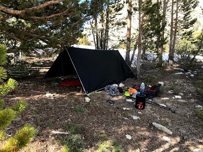
The afternoon went a lot better and I had a similar time trying to make camp. From the low point of 10,000' between Mather Pass and the next pass called Pinchot Pass, there were still a lot of snow and I couldn't see any obvious place to set up camp so I kept going. I kept going and going and jumping over snowy creeks and post-holing all the way to about 10,500'. Everything around me and in sight was covered in snow but I somehow kept going with some hope of finding a dry place to camp. Whenever I see a group of trees, that shows me potential of some dry land but these "dry" areas were sloping, wet, and still congested in the trees. Eventually, I cross country hiked to this unnamed lake at 11,000' and miraculously, the entire north side of the lake is dry as a bone! I had the whole place to myself and it was one of the most beautiful camps I've ever set up. I found it amazing how for only a $5 fee, I could hike out here, witness, and experience this place all to myself.

My camp for the night. Organized chaos.

Brilliant views at an unnamed lake all to myself
I got to camp at 2pm but didn't want to hike past this point as I'd be slipping around over the pass so I took a nap, set up my shelter, stretched, waded in the water, let my clothes dry, ate lots of food, and enjoyed every minute of this beautiful camp.
Day 4:
Since I didn't go up Pinchot pass last night, it set me up to complete nearly 30 miles in the next 2 days. I decided to plan on a 17 mile day and hike all the way to Rae Lakes, which was a past favorite spot of mine to camp. It must have been my 4th trip going to Rae Lakes and I was still looking forward to it. I woke up early and hit the trail aiming to be up and over Pinchot Pass before the sun hit. After lake Marjorie, the last large lake before the pass, everything in front of me was snow except for some random rock outcroppings.

Top of Pinchot pass - Absolutely beautiful but... where's the trail?
I didn't see a clear foot path to follow so I just start hiking up and later did I realize I was hiking on top of the frozen creek between the lakes up there. It was some really fun hiking to get to the top of the pass and I was up and over no problem. Fortunately, I started early and had no troubles in the snow because I didn't meet up with the actual trail until nearly 5 miles after the pass once I was hiking along Woods Creek. I read my maps and made sure I was on the right side of the river and stayed in the correct general area and had no problems.

Lots of XC hiking. Good thing I know how to read a map (Thanks Dad!)
Unfortunately, this is about when my phone died and I had to take mental pictures from here on out. I stopped at the foot bridge crossing of woods creek and had some lunch. I had already hiked 10 miles by now and the next few miles of trail didn't seem to difficult so I rewarded myself with a long lunchbreak involving laying out and soaking my river by the river, making oatmeal, and relaxing in the shade.
After hiking to Dollar Lake, I was getting tired of my shoes so I switched into my Teva sandals and hiked the remaining 2.5 miles in those which was surprisingly comfortable. Just before Arrowhead lake, there was a waist-deep river crossing that I decided to take my pants off for. Just as I'm ankle deep, I see a couple of hikers, first I've seen in a few miles. Without shame, I kept on and hiked right past them in my undies and watched their faces get red. I dried off and put my pants back on after so don't worry. I got to Rae lakes in the mid-afternoon and tried to experiment with my shelter setup and ended up going with the hammock and tarp shelter usual setup. Turns out 4 days deep into a trip is too late to learn different varieties of how to set up a tarp shelter. The timing is ironic that now that I was camping at Rae lakes, one of most iconic JMT views, a view I had been looking forward to all springtime long, and my phone died so I couldn't take a picture! I take my non-existent artistry skills to work and create a pencil drawing of what I saw which my super talented artist of a wife appreciated. There were beautiful clouds rolling through the high mountain peaks, old wind-scarred trees spotting the area, and colorful granite bluffs poking up through the crystal clear trout-filled lakes. Great day and the 17 miles didn't do me over.
Day 5:
Day 5 starts with the very end of day 4 where I realized since I didn't have a phone with a charge, how could I set my alarm? I need to hike 13 challenging miles of trail and be back in time to hitch-hike back back to my car. Also, Glen pass had a super treacherous steep snow field and I could not hike it when it was sloshy in the late morning. I went to sleep with the faith that something somehow will wake me in time.
4:30am on Day 5, I heard the morning birds start to chipper and even though it was dark out, there were slightly less stars. Then I figured it wasn't 11pm, but it must have been early morning and I could get ready. As I'm taking down my shelter and packing my bag, I start to see the black sky turn into dark blue in the east. YES!! My body clock worked! Immediately when I hit the trail, the usual morning feels are feeling (if you know what I mean) and I hike away from the creek and up the hill a ways to a good spot. Not until the business was done did I realize I had like 1 sheet of TP! So I pull out my journal, cut out a few pages, and fabricate some make-shift "mountain money" as my Father-in-law would call it. Anyway, I start hiking up Glen pass and found it beautiful, enjoyable, but also extremely sketchy and snowy. I bumped into some other hikers that were doing the JMT SOBO and they let me use their phone charger which brought me from 0% to 40% so I could take pictures and use my phone in town if needed. I was worried I would have trouble hitch-hiking and couldn't let my family know I was back from the mountains, but worry no more!

Hiking up Glen pass

Charlotte Dome from the JMT
At the top, I said a big thank you to my hiker friends and then starting moving fast towards Kearsarge pass. While hiking down Glen pass, I saw Charlotte Dome in the west where Paul, Chris and I climbed in 2018 it being the most memorable climbing trip to date. I took the longer path so I could hike past Bullfrog lake. There, I take my shoes off to rest my feet and notice my shoes were steaming from the heat!

Great lunchtime break spot at Bullfrog lake
At the top of Kearsarge pass, I meet another hiker named Greg who is another avid backpacker in the Sierras and not just another PCTer who is doing it from the 'gram. We had a great conversation while hiking together on the way down and he offered to drive me back to my car! I ended up back in town with my car in the mid-afternoon with plenty of time to drive home. Thank you Greg!

All smiles on Day 2 of 5
All in all, this was a fantastic trip backpacking in the Sierras and a repeat of one of my favorite sections of the JMT. I was stoked I was able to pull off all 63 miles in 5 days with plenty of time to relax and soak in the scenery. I received some much need solitude and plenty of rest since it gets cold as soon as it gets dark. I completed the trip feeling inspired, awake, alive, and extremely grateful that I live in a part of the world with the privileges I have to be able to do things like this for fun. I am extremely lucky for each minute I spend in these mountains.

Hiking up Palisade Creek looking back towards Devils Crags

Incredible suncups looking towards the North Palisades and Isosceles peak

My route highlighted in Orange. Campsites in blue.
63 miles, 13,000' elevation gain, estimated 50% XC hiking, average elevation is 10'400'.


This is amazing! I’m glad that your body clock worked and you stayed safe and had a fun and peaceful time!
ReplyDelete